| Friends Of The Little Bighorn Battlefield |
The Next Generation In The Study Of Custer's Last Stand |
Little Bighorn Flood May 2011 |
| • The Battle • Archeology • Memorials • Little Bighorn Store • News • Book Reviews |
May 21-22, 2011Photos of FloodsPhotos below courtesy of Mike Donahue
Photos below courtesy of Sandy Watts
Photos below courtesy Custer Battlefield Museum, Garryowen,MT
Before and after photos
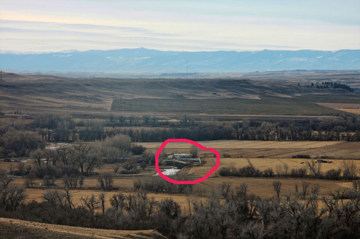
Reece photo shot in 2005. See farm house circled in red
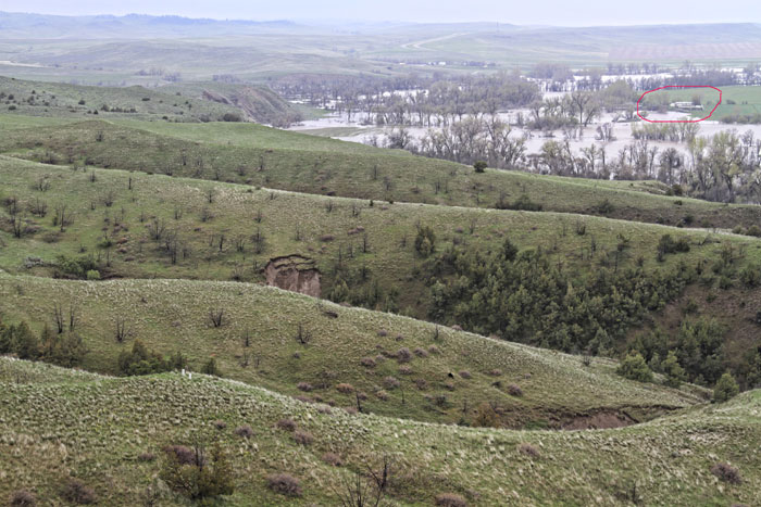
Donahue's flood photo, see same house circled in red
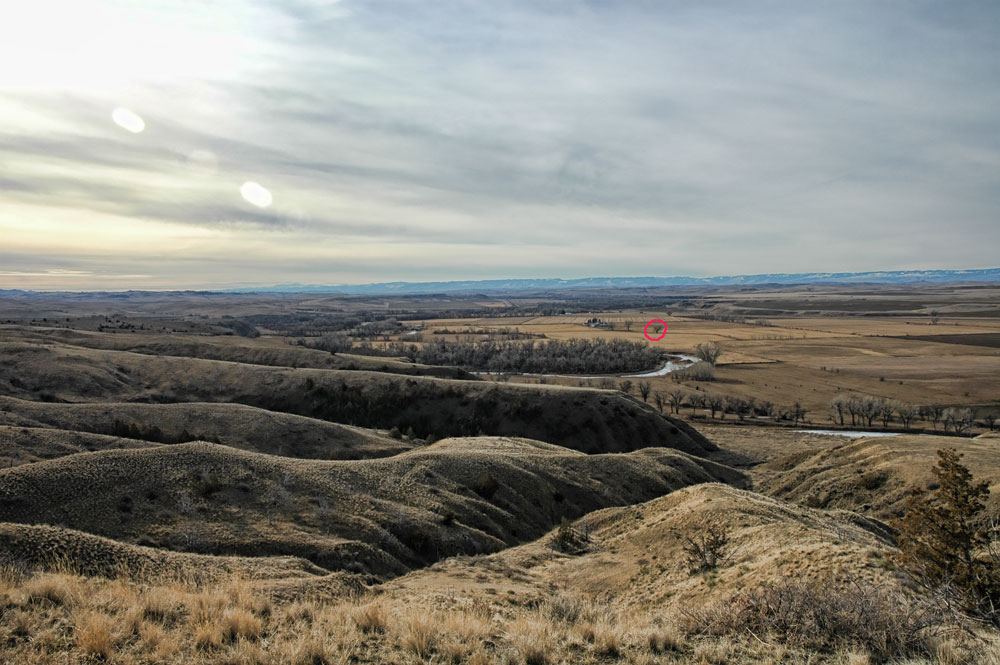
Reece photo shot in 2005. See tree circled in red
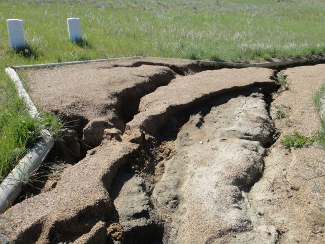
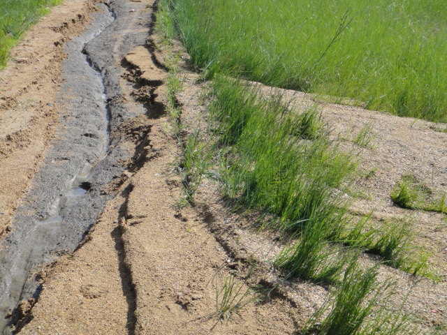
Donahue's flood photo, see same tree circled in red Photos of erosion damage to Deep Ravine Trail, photo courtesy Little Bighorn Battlefield National Monument
Update June 21, 2011 -- Deep Ravine Trail should be open in time for anniversary. Flood Update June 7, 2011 --
In an email, Acting Superintendent Barbara Johnson provided encouraging news
regarding the temporary closing of Deep Ravine Trail due to damage from water
erosion. She has her team working as best and as fast as they can to try and get
the trail open in time for the anniversary. This flood may be a godsend for the location of a possible new visitor center as Ms. Johnson notes. NPS does not want to build in a floodplain.
Jump here for photos of the damage to the trail.
Ms. Johnson notes: Flood Update June 6, 2011 --
Just spoke with Mike Donahue. Heavy rains over the last month have wreaked
destruction along Deep Ravine Trail with some areas washed out. Result is the
trail is temporarily closed. Not sure for how long. Bluffs between Weir Point
and Reno Benteen Battlefield have erosion in many places. Photo from Donahue
above shows example of some damage. Many people who live along the river have a
lot of property damage. Acting Superintendent Barbara Johnson told me in an
email that last month’s flood “was the highest recorded...about a foot higher
than 1978”. Donahue told me that he heard this flood was equivalent to a 500
year flood. We will keep you posted in regards to Deep Ravine Trail. Update May 25, 2011 -- Acting Superintendent Barbara J. Johnson in an email stated, "I opened the park today - I see some limited vehicular traffic on I-90 and we have had some visitors. The water is receding. We have had non-stop calls from folks wanting to come in - it is a very popular National Monument!" Our prayers are for the residents that live along the Little Bighorn River and for their speedy recovery from this flood. Update May 23, 2011 -- The battlefield webcam shows the water level of the Little Bighorn River has lessened. That is good news. I haven't heard from anyone at the battlefield yet today. May 22, 2011 -- Mike Donahue told me that the Little Bighorn River is flooding due to snow melt and rain. I-90 is closed between Sheridan, Wyoming and Hardin, Montana. The interstate across from the battlefield is under water. However, Hwy 212 is still open. Flooding is bad in Lodge Grass. Original Friends board member, Linda Pease, told me that the water is up to the windows in the Lodge Grass post office.
Some of the staff cannot reach the battlefield. Crow Agency has
volunteers filling sandbags. As a result, the battlefield is closed Sunday and
Monday. Not sure when it will open. Portions of the Deep Ravine bank have caved in. Chief Curator Sharon Small told me that Sunday morning people could get through to the battlefield from Hardin via the frontage road going through Crow or the back road by the college, but by the afternoon it was impossible. The water is pouring over the interstate by the weigh station and across the frontage road. The Bighorn is full as well with water surrounding the fire works station off of I-90 exit into Hardin. Hwy 313 to Fort Smith is closed, HWY 314 Decker road is closed and it continues to rain off an on. Retired Chief Historian John Doerner sent me an email this evening (Sunday May 22). He reported that "the Big Horn River is also flooding and my neighbor informed me that the local Fireworks Retail Store adjacent to the I-90 Bridge is an island now. This is a major lesson for those that propose building the LIBI visitor center in the valley, which is on a floodplain!" Note by Bob Reece: For me, I think a new visitor center should be built on the bench lands to the west of I-90. I've always advocated that the ideal location would be the old Denny property which is directly west of the Reno skirmish line area. From those bench lands (where the Indian village pony herd grazed prior to the battle) one can see a complete panorama of the battlefield from Last Stand Hill to the north and the area where Reno entered the valley to charge upon the village far south. Back To Home Page |
|||||
|
Copyright 1999-2013 Bob Reece Friends Little Bighorn Battlefield, P.O. Box 636, Crow Agency, MT 59022 | Home |
Board of Directors |
Guest Book | Contact | Site Map
| |